

By Sunayana Prabhu
RED BANK – The borough is using data mapping technology to improve municipal infrastructure management, working on making Red Bank’s roadways safer and more drivable. Borough manager Jim Gant recently provided updates about the borough’s 2025 road improvement project and information about the technology program’s progress.
“The 2025 road program includes roadway improvements to Allen Place, Boat Club Court and Alston Court, as well as drainage improvements to River Street and water utility and sanitary sewer improvements to Hubbard Park,” Gant said in an email.
“These roadways will be milled and paved, with removal of deteriorated concrete curb, installation of ADA curb ramps and detectable warning devices, traffic striping, the reconstruction of all inlets and the installation of bicycle safe grates,” he said.
According to Gant, the borough engineer’s estimate for the utility and road work was approximately $1.15 million. The lowest bid – about $1.1 million – came in the last week of March.
Last year, the borough contracted with Vialytics, a company founded in Germany with a mission to “revolutionize road maintenance through cutting-edge technology,” according to its website.
The Vialytics mobile app is installed in borough-run vehicles to collect image data during routine drives around town. It uses artificial intelligence (AI) to automatically detect road damage, such as cracks and potholes. This real-time data assists the borough’s Department of Public Works employees in tracking, planning and improving maintenance projects in town.
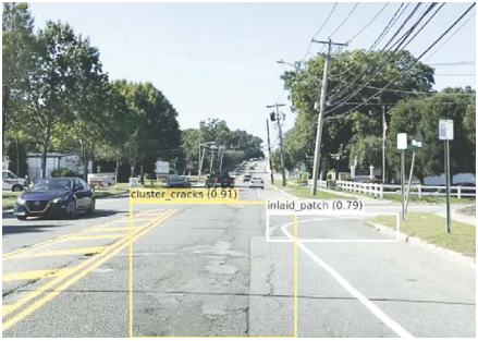
According to a presentation shared by Gant, the Vialytics technology supports both short- and long-term infrastructure planning by offering AI-powered reconstruction proposals. It also helps identify damage to manholes, catch basins and street signs and keeps a complete history of maintenance work.
Additionally, the system helps municipalities respond to extreme weather events like flooding, snowstorms and hurricanes by assessing road and asset damage, securing FEMA funding, and tracking winter services such as salting and plowing. According to the company, by utilizing the technology, municipalities can extend the lifespan of their roads and manage infrastructure more effectively while saving time and money.
Borough employees have been using the data provided by the program for more than eight months. In that time, “we’ve mapped over 38 miles of borough roads to get that baseline data of what the condition of the roadways are, to prioritize maintenance tasks,” Gant said during the March 27 borough council meeting.
He said the Vialytics system has already assisted DPW employees in tracking and completing nearly 100 maintenance tasks across the municipality, ranging from street sign replacements to infrastructure issues. “Tasks would include changing out disrupted or dirty sticker signs, repairing potholes, and addressing brush and curbing issues,” Gant said.
The app has cataloged everything from vehicles to playground equipment and even shade trees in the borough. The technology has already mapped critical infrastructure components in the borough, including more than 800 manhole covers, nearly 300 storm drains and more than 1,000 street signs. “The inventory helps us prioritize maintenance and ensures longevity of the underground infrastructure as well,” Gant said.
The borough used Vialytics data to identify Chapin Avenue for the 2025 New Jersey Department of Transportation (NJDOT) grant, providing precise documentation of where the road needs repairs, where potholes exist, or other conditions creating hazards. “You can actually see where the road is coming apart in that area,” Gant said, adding that the technology is “going to be a great, useful tool to help us budget and actually make decisions based on real situations instead of just complaints that come in.”
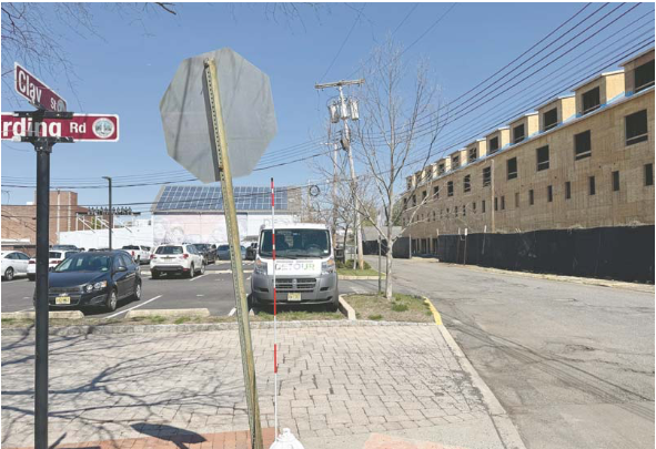
Gant said the app identified Clay Street as one of the worst in the borough. “That’s on our radar,” he said, explaining that while immediate repairs will wait until nearby construction is complete, the program provides clear documentation of the street’s condition.
An upcoming app feature will track crosswalk and street marking conditions, which could further enhance the municipality’s infrastructure management capabilities.
The article originally appeared in the April 10 – 16, 2025 print edition of The Two River Times.


