By Emily Schopfer
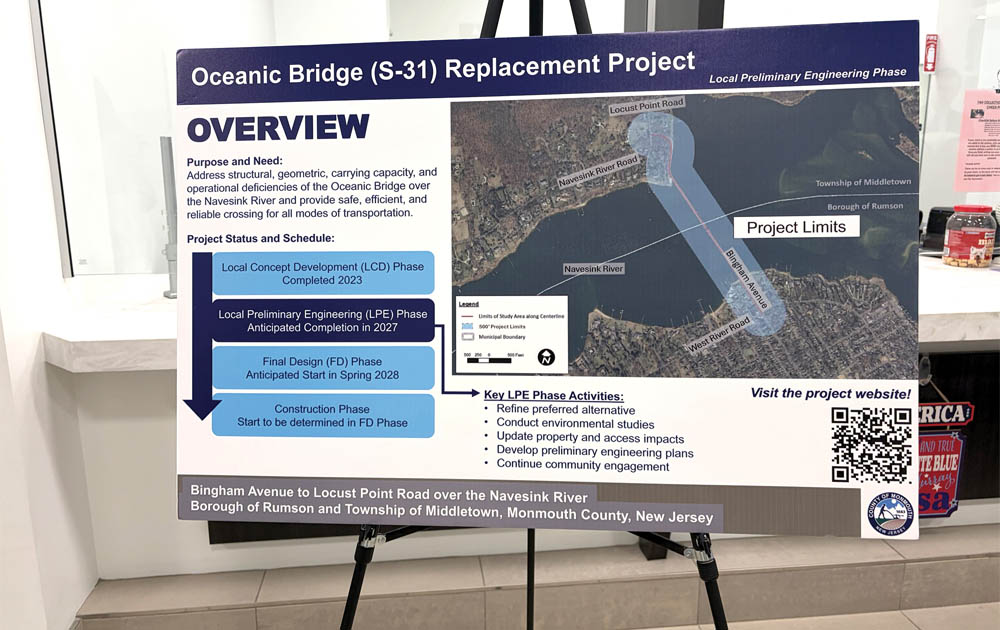
MIDDLETOWN – Monmouth County officials held a public information session Sept. 29 to review the latest plans for the Ocean Bridge Replacement Project. The two-hour session at the township hall drew officials and residents from both Middletown and Rumson, along with project experts from the county, consulting firm Michael Baker International, the New Jersey Department of Transportation (NJDOT), and the North Jersey Transportation Planning Authority (NJTPA).
After years of back-and-forth among residents, the U.S. Coast Guard (USCG) and the county over style and dimensions, the new span will be a fixed 65-foot-high bridge, Monmouth County engineer Joseph M. Ettore said. “In order to stay eligible for federal funding, that was really the only option the county was given,” Ettore said.
“Unless the county was willing to fund it with taxpayer dollars, we really had no choice but to move forward with that option,” he said.
The USCG, in a Preliminary Determination of Navigational Clearance Letter dated March 25, 2019, recommended a fixed-bridge height of 65 feet, resulting in a roadway height of 81 feet.
Ettore said the decision to build a fixed-span bridge instead of a drawbridge created the controversy. County officials, Middletown Mayor Tony Perry, and even former Gov. Phil Murphy all challenged the 65-foot USCG recommendation, instead pushing for a 55-foot clearance.
But Ettore said 65 feet matches the clearance of the Route 36 Highlands-Sea Bright Bridge, the first entrance to the Navesink River, and that keeping both bridges at the same clearance allows both rivers to be accessible.
Stephen Smith, a member of the board of directors for the Monmouth Boat Club in Red Bank, said the club is “so happy that it’s stayed the same height as the bridge between Highlands and Sea Bright.” If the two bridges were different heights, “you can get in one, but not the other one,” Smith said at the session.
Bridge Footprints
According to the presentation, the new fixed bridge will eliminate a drawbridge’s impact on vehicle and marine traffic. Additionally, the “substandard” curve at the entrance to the bridge in Middletown will be replaced with a roundabout and the speed limit will be reduced to 35 mph.
While the new bridge will align with the existing footprint on Rumson’s Bingham Avenue, the new roundabout will create a new bridge footprint in Middletown. The new bridge entrance will sit slightly north of the existing entrance, which will be turned into a recreational, public waterfront access space.
The planned roundabout at the intersection of Locust Point and Navesink River Roads currently has a traffic light. That is a “high crash location,” according to Ettore. “We needed to better control the traffic. The roundabout slows traffic down, and it reduces serious injury by 78%,” he said. Because traffic flows in the same direction, Ettore said, most accidents in roundabouts are sideswipes, not 90-degree collisions. “In Monmouth County we’ve been very aggressive with building roundabouts; we have one at Brookdale, we have the one in Colts Neck, we have the one in Interlaken… I think we’re probably one of the leaders in the state in terms of county level because we found how effective they are in reducing crashes and injuries,” Ettore said.
Community Access
In addition to a greater focus on traffic safety, the new Oceanic Bridge will also focus on accessibility for pedestrians and bicyclists. The traffic lane widths will be reduced from 12 to 11 feet. Rather than replicating the existing pair of six-foot-wide sidewalks on either side of the bridge, the new bridge will have one 14-foot-wide shared-use path with a barrier on the western side, plus scenic overlooks. To further improve accessibility for pedestrians and bicyclists, the bridge’s slope will be modestly reduced to ease the steepness.
These enhancements, Ettore said, came from public input, but since the original project, one of the county’s primary goals “was the multimodal use of the bridge.”
“The bridge has always been actively used by pedestrians and cyclists,” he said. “It’s a beautiful river… so we, the public, made good use of that.”
“This refinement doesn’t change the capacity of the bridge to carry vehicles,” Ettore emphasized, “but it makes it more safe for pedestrians and cyclists.” He added that, while not shown on the project plans, overhead lighting will likely be installed on either side of the bridge.
The shared-use path will connect to the new waterfront access space on Middletown’s side. In Rumson, the plan is for the pedestrian path to connect to Victory Park, southwest of the bridge at West River Road and Lafayette Street. However, how the path will connect is still undecided. According to the presentation, there are three options. Option A is a 14-foot path from the bridge (Bingham Avenue) to River Road. This plan would require changing existing parking spaces to angled spaces, losing five spaces and changing to one-way traffic. Option B would be a 10-foot path from the bridge to Hunt Street, which connects to Victory Park. Option C would be a riverfront path, connecting the bridge to Washington Street. The bridge’s shared-use path is about 17 feet high at this location, so ramps would be needed.
Several Middletown residents, mostly from the Navesink section of Middletown, who spoke to The Two River Times Sept. 29, expressed concern about the new roundabout’s impact on residents and how the pathway would connect to Rumson’s Victory Park without disrupting local traffic patterns.
Project History
The project has been in the Local Preliminary Engineering (LPE) phase since April 2025. County officials awarded a $4.9 million preliminary engineering and design contract to engineering and consulting firm Michael Baker International in fall of 2024. Several representatives from Michael Baker International also attended the information session to answer questions.
The LPE phase is fully funded by a $4.97 million federal grant awarded in February 2025. Final cost for the entire replacement project will be determined by contracts awarded after the project goes out for bid.
Constructed in 1939, the existing double-leaf, bascule bridge connects Rumson and Middletown over the Navesink River. In July 2021, the bridge was classified as “structurally deficient” by the U.S. Department of Transportation (DOT).
“Due to its age, the bridge has deteriorated over time, and routine maintenance can no longer address the deficiencies,” according to the Oceanic Bridge (S-31) Replacement Project’s official website. The website also states that the bridge is “structurally deficient (poor condition), functionally obsolete (substandard geometry), and nearing the end of its service life,” noting heavy rust, corrosion holes and “wide cracking; deep spalls (cavities); exposed and severely rusted reinforcing steel; deteriorating steel pile jackets (protective sleeves); and exposed steel H-piles (beams in an H shape).”
The need for replacement is largely undisputed. The crux of the matter was whether the new bridge be fixed or movable like its predecessor. When closed, the current drawbridge’s navigational clearance is 22 feet above the water at mean high tide.
Timeline
Each phase of the project is projected to take two years from start to finish, with final construction depending on the project design. According to the presentation, assuming no major setbacks, the project will move out of the Local Preliminary Engineering (LPE) Phase in fall 2027 and into final design by spring 2028.
The Oceanic Bridge project is federally funded; it will go out for competitive bidding once final design is complete. Even once a contract is awarded, final costs may vary significantly due to change orders or other project setbacks.
“I will assure you of one thing,” said Monmouth County Commissioner Director Thomas A. Arnone, “that when this bridge is done, it will be the signature – not just the best – but the signature bridge in my eyes, in the state of New Jersey.”
The article originally appeared in the October 8 – 14, 2026 print edition of The Two River Times.