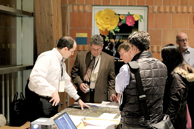
Residents concerned with rising water levels in the Shrewsbury and Navesink Rivers look onto maps provided by Rutgers University. By Jay Cook
RED BANK – While water quality in the Navesink and Shrewsbury Rivers has been a hot-button issue in the past year, concerns have now shifted toward the future water levels of those rivers.
On Feb. 23 at the Two River Theater, the Department of Environmental Protection (DEP) unveiled the NJ Fostering Regional Adaptation through Municipal Economic Scenarios (FRAMES) program. The approximate three-year project will concentrate on planning for potential costal hazards and possible sea level rise through year 2100 throughout 15 municipalities in the Two River area.
According to Liz Semple, manager at DEP’s office of coastal and land use planning, the process relies heavily upon conversations between the DEP and the residents in the highlighted areas.
“It’s their homes, the roads in front of their houses and the beaches that they go to,” she said. “The people need to be a part of the decision making.”
The DEP applied for and received a $898,656 grant from the National Oceanic and Atmospheric Administration (NOAA) for the NJ FRAMES project. Semple said it was one of 15 projects funded by NOAA nationally.
The 15 towns included in the project are Eatontown, Fair Haven, Highlands, Little Silver, Long Branch, Middletown, Monmouth Beach, Oceanport, Ocean Township, Red Bank, Rumson, Sea Bright, Shrewsbury, Tinton Falls and West Long Branch.
Now in the preliminary phase, Semple said the agency is gathering feedback from residents about where improvements can be made along potential flood sites.
“If there’s certain shorelines that are protecting vulnerable communities, or community assets that are most important to the towns, then we’ll work with them which actions are best to protect those,” she said.
Semple referred to post offices, police stations, fire houses, and costal evacuation routes as potential areas that could have more protection or possibly be moved when resident feedback is returned.
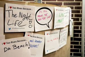
Tasked with the community outreach is Lisa Auermiller, a watershed coordinator with Rutgers University. Both the university’s Climate Institute and the Edward J. Bloustein School of Planning and Public Policy have partnered with DEP to conduct the science behind the future sea levels. At the kids table, children created signs and artwork detailing their affection for the Two Rivers area.
At their respective station, Rutgers University had a maps of potential flood areas along the Two Rivers and the Atlantic coast.
“We’re documenting what works and what doesn’t, and at the end we’ll go back to NOAA with the lessons learned,” Auermuller said.
With the Jacques Cousteau Reserve, Auermiller said data-gathering will also be done through a mobile app – SeaLevelRise. Residents can sign up for free and drop virtual “pins” onto areas they deem problematic or worth a look. So far within the NJ FRAMES town list, four makers have been placed in Long Branch, all within three blocks of Route 36.
The NJ FRAMES program will also lean on stakeholders who are familiar with the discussed areas. Groups such as the Two River Council of Mayors, Clean Ocean Action, American Littoral Society and NJ Sea Grant Consortium (NJSGC) will all pitch in and play a part in finding the best resiliency options.
“People can come to us, along with others in the consulting group, to propose ideas,” said Dr. Amy Williams, a costal ecologist at Stevens Institute of Technology, who also partners with NJSGC. “We’ll see if there are any red flags or ways to do it better.”
Williams added that NJ FRAMES is unique in that it focuses on a large regional level compared to one-or-two-town projects. Because of that, she said, there need to be checkpoints along the way.
“We’re the people making sure no one’s taking too many steps forward without checking all the rules and regulations,” Williams added.
During the two-hour event, roughly 80 people from the Two River region came to learn more about the project and what part they could play going forward.
“I’m very much interested in climate change and how to communicate it,” said Steve Miller, a Middletown resident. “There’s a lot of work going into all of this, and it seems like they’ve deliberated all sorts of solutions.”
After Super Storm Sandy, Miller said he was part of an action group formed by his parish, Lutheran Church of the Good Shepherd in Holmdel, to raise money and gather resources for those affected by the storm.
Also a former Long Beach Island resident, he said the flooding issues in the past are akin to those now in Monmouth County.
“That didn’t happen 40 years ago, and it’s happening now,” he said. “It’s a lot, and I think it’s a taste of what could happen in the future.”
After finishing up at the kids’ area with her son, Otto, Kate Triggiano, who lives on the West Side of Red Bank, said climate change science is paramount to understanding these coastal flooding issues.
“Once people are informed, they care,” she said. “Without that information, it’s hard to make that impact on someone.”
Her motherly instinct also kicked in when thinking about the future.
“I do think about what the world will be like for kids now,” she said. “I was active and involved before he was born, but the second he was born, I felt a switch go off.”
Resiliency plans will start to roll out within the next year and a half, according to Semple, the DEP manager. NJ FRAMES representatives will also make stops at the 15 municipalities during that time to continue their data-gathering campaign.
To learn more about the NJ FRAMES project, visit www.nj.gov/dep/oclup/njframes-area.html.