

By Jay Cook |
FAIR HAVEN – Walking and biking have long been prized in Fair Haven’s small, riverside community. And now active outdoor enthusiasts are expressing satisfaction that a years-long initiative aimed toward widespread roadway safety is complete.
For years, Fair Haven has been pushing for safer streets, said Mayor Benjamin Lucarelli. On any given school day during the warmer months, up to 700 students commute via bicycle to the local school and back home. Lucarelli and fellow Two River mayors zealously pushed for the inclusion of bike lanes along Ridge Road and eventually accomplished that in 2015.
It was a goal that became urgent for the borough after two tragic deaths on its roadways from biking accidents. Shrewsbury firefighter Cole Porter died from his injuries after his bike collided with a referee in the 2013 Tour de Fair Haven bicycle race, and borough councilman Jerome Koch died a day after his bike collided with a vehicle on River Road in 2014. Since 2011, the Dept. of Transportation says there have been six other bike and pedestrian accidents in the 2.1 square-mile town.
This week, the borough Planning Board formally approved the Fair Haven Active Transportation Plan. The detailed, layered plan lays the groundwork for roadway and safety improvements to further protect Fair Haven’s biking, walking and jogging community.
“Talk to the folks that grew up in this town,” Lucarelli said this week. “It’s exactly what they did back then, there were just a lot less cars. It’s not something that’s new to our lifestyle. I think it’s integral to the lifestyle that attracts people to Fair Haven.”
The project and report were funded by the state Department of Transportation and assisted by Rutgers University and WSP USA, a civil engineering firm. Lucarelli asked residents and stakeholders to take part in the process to provide insight.
One of those residents was Gail O’Reilly, a Fair Haven resident of 27 years and a former professional city planner. For those who use the Route 35 Cooper’s Bridge to and from Red Bank, she is the advocate who ensured the bridge had bike lanes when it was replaced and rebuilt years ago.
“There is a longstanding level of support and a high level of expectation for this topic here in town,” O’Reilly said this week when talking about the plan.
As noted in the introduction to the transportation plan, Fair Haven residents were surveyed in 2016 about their thoughts on the borough’s existing roadway amenities. The report found that 75 percent of all students in town go to school via bike or by foot, and two-thirds of respondents said they would walk or bike more in town if pedestrian and biking facilities were improved.
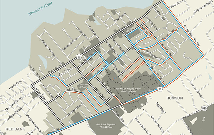
A widespread plan for improving all of those options was addressed in the study. Among the proposed improvements are installing sidewalks, mostly in residential neighborhoods where some don’t exist, and enhancing pedestrian crossings with new features like additional signage, with lighting and striping crosswalks at all intersections. The plan also highlights constructing sidewalk bump-outs and installing speed humps and other traffic calming initiatives. More noticeable and identifiable bike lanes throughout the community were also highlighted, considering the high usage of the existing ones.
The plan will help map out what improvements can be made to different roadways over the next decade and beyond.
“To not only be able to travel safe within the borders of our community, but to make connections beyond those borders, that would be a very lovely outcome,” O’Reilly said.
Input from the community was invaluable, Lucarelli noted. In addition to a few open houses to present updates and information, an online “wikimap” tool was launched for residents to mark up the locations in town which concerned them. Ninety-one users left 25 comments on the map, with River Road coming up as the most discussed portion.
Both O’Reilly and Lucarelli agreed River Road poses the most challenges from a safety standpoint. Known as County Road 10, it was noted as having a Level 3 and Level 4 bicycle stress level, the two highest possible in the report.
Six pages in the final Fair Haven Active Transportation Plan list the cost estimates and different traffic calming or roadway improvements that could be implemented in Fair Haven.
For Lucarelli, establishing safer roads is paramount.
“Everybody’s primary concern is the health and welfare of our children,” he said. “This serves to reinforce what their rights and obligations are, just as it is to serve the motorist.”
This article was first published in the March 15-22, 2018 print edition of The Two River Times.


