The 24-mile Henry Hudson Trail has received multiple grants and undergone multiple renovations in the past to unify the now three-part trail’s disjointed sections: the Bayshore Trail from Highlands, running north toward Keyport and Aberdeen, and two western sections through Marlboro and Freehold.
EMILY SCHOPFER
By Emily Schopfer
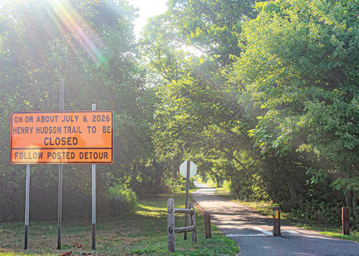
MIDDLETOWN – About a half mile of the Henry Hudson Trail in Port Monmouth will be closed for the next two years beginning July 6. The closure is part of the second and final phase of the U.S. Army Corps of Engineers’ Port Monmouth Coastal Flood Risk Management Project, a more than a decade-long project to reduce the area’s increasing flood risk.
The impending closure will affect the trail between Wilson Avenue and Church Street. The closure will detour walkers, runners and bicyclists up to Wilson Avenue and Main Street, across Broadway, and back onto Church Street to reconnect with the trail going south. This detour will add a little over a mile to the route.
About two to three miles of the 24-mile-long Henry Hudson Trail passes through Port Monmouth. The trail stretches from the Bayshore Extension portion in Highlands and Atlantic Highlands, north toward Aberdeen, and back south through Marlboro and Freehold in the western part of the county.
The area “has been under construction since 2013 after the devastation of Hurricane Sandy,” according to the U.S. Army Corps of Engineers, New York District. When completed, the project will consist of a “flood wall, road closure structures, tide gate, pump station, road raising of Port Monmouth Road and, regarding Route 36, utility upgrades.” According to the Army Corps, the project is “slated to be complete by end year 2028.”
Phase One of the two-phase “extensive $110 million hurricane and storm damage risk reduction project” started in June 2014, according to a July 24, 2014, release by the U.S. Army Corps. U.S. Rep. Frank Pallone (D-6), announced the beginning of the $61.8 million Phase Two in November 2024.
The project has also been referred to as the Raritan Bay and Sandy Hook Bay, Port Monmouth, NJ Hurricane and Storm Damage Reduction Project. In a public information session in January 2023 in Middletown, the U.S. Army Corps of Engineers and the New Jersey Department of Environmental Protection explained that Phase Two of the project was to be completed through five contracts, not necessarily in numerical order.
According to a Jan. 13, 2026, project fact sheet available on the U.S. Army Corps of Engineers New York District’s website, the contracts in order of completion are: Contract 3, a flood wall along Port Monmouth Road and construction that was completed July 2019; Contract 2 was completed in August 2020 and focused on building a 40-foot-wide flood gate and pumping station north of Pews Creek in northern Port Monmouth, close to Middletown’s Ideal Beach; Contract 4a focused on Route 36 pavement raising and Main Street electric utility upgrades, completed in 2020; Contract 4b, a flood wall and levee system along Route 36 along Creek Road to Broadway is ongoing and is what will impact the Henry Hudson Trail starting July 6; Contract 5, a flood wall and levee system along Main Street and pumping station on Main Street is also ongoing; and Contract 1 is an umbrella contract for both Contracts 4b and 5.
The project ultimately will provide protection to the low-lying residential and commercial structures in Port Monmouth that sit upon both salt-and fresh-water marshes. Much of Port Monmouth is classified as Flood Zone AE by the Federal Emergency Management Agency (FEMA). This means that the area is at high risk for flooding with a 1% chance of flooding annually and an approximate 26% chance of flooding over a 30-year period.
While a 1% chance may not seem like a large problem, Middletown Township administrator Tony Mercantante said Port Monmouth north of Route 36 is well below the base flood elevation for the area, as are some portions south of Route 36. Below base flood elevation means that an area is at a lower elevation than what floodwater levels could reach during a major 100-year flood, or flood event with 1% chance of occurring in a year.
Coupled with continued beach erosion that has been removing protective structures such as dunes, this leaves the area susceptible to flooding from heavy rainfall, storm surges or further beach erosion.
When completed in 2028, the entire project will consist of “the construction of about 7,070 feet of levees, 3,585 feet of flood walls, 2,640 feet of dunes, and beach re-nourishment at 10-year intervals along the Raritan Bay and Sandy Hook Bay in Port Monmouth,” according to the January 2026 fact sheet.
“As with anything like this, we would love to see it completed sooner than later. However, we understand that large complex projects like this can be slow moving,” Mercantante said regarding Phase 2 of the project.
Mercantante said the township is “very confident” that once completed, this project will at least help to reduce the flood risk to Port Monmouth. “Look at North Middletown – their levy was built in the early 1970s and it still protected that neighborhood completely, even during Hurricanes Irene and Sandy,” he said.
While the land for the Henry Hudson Trail is owned by New Jersey Transit, the trail is administered and managed by the Monmouth County Park System.
“The Henry Hudson Trail detour is necessary to accommodate the U.S. Army Corps of Engineers’ Port Monmouth Flood Control Project, and the project’s schedule is determined by the contractor in coordination with the Army Corps and project stakeholders,” said Monmouth County officials in a July 1 statement. “Monmouth County Park System staff have worked closely with the Army Corps and Middletown Township to plan and implement the detour. The detour will remain in place for the duration of the project and is clearly marked for trail users to ensure the safety of cyclists, pedestrians and motorists.”