

Photo courtesy GIS-MonmouthN.OpenData.ARCGIS.com
Residents can now access a trove of open data at the new Monmouth County, NJ GeoHub website, a two-year project created by the Monmouth County Division of Planning in cooperation with the freeholder board.
Users can download open data and use interactive web maps and applications to find open geographical, topographical and environmental data, such as property and parcel information for engineering and tax purposes. They can also link to external geographic information system mapping from state and federal agencies and even take a “tour” of Monmouth County’s historical areas.
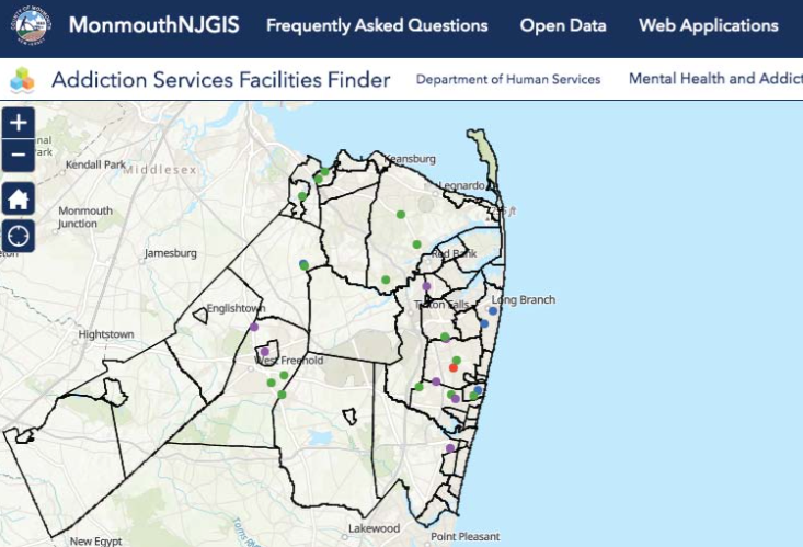
And one integral aspect of this database is the built-in location finder for addiction and mental health services facilities, found under the Web Mapping Application tab.
“One of the most important things we discussed at our recent municipal alliance meeting was how to get the word out about these service facilities,” said freeholder and Assemblyman-elect Gerry Scharfenberger. “How do we put this information at the fingertips of those who need it most, because sometimes the people who are caught up in addiction or in a mental health crisis want help, they just don’t know where to turn.”
By zooming into the addiction services finder map, a user can learn where to find four different types of facilities in local towns, including multiservice facilities, outpatient care, residential and preventative services.
Mental health services are divided into nine different categories, including general health, legal services, adult mental health, mental health for children, multiservice facilities, psychiatric emergency services, social services, specialized education and substance use disorder.
“This is such a critical aspect of this (GeoHub) because in severe cases resources and information could very well be the difference between life and death,” said Scharfenberger.
He noted the sobering statistics on overdose deaths and deaths related to heroin and opiates compiled by the Monmouth County Prosecutor’s Office over the last eight years. Since 2012, the county has recorded 1,071 overdose deaths, including 962 fatalities linked to heroin and opiates.
Among the other health and safety information included in the GeoHub is the “Know Your Zone” application that lists the various evacuation routes for coastal communities that are prone to dangerous flooding events, from the Monmouth County Sherriff’s Office.
Meghan Levy, Monmouth County Geographic Information System (GIS) services manager, described the GeoHub as an educational resource for county students and educators to connect their course work with local culture and history through interactive story maps.
“It’s about accessibility. Not everyone has the ability to get in a car and spend a day driving around to the different cultural and historical sites around Monmouth County. Not every school system has the resources to organize class trips. Part of our mission was not only to provide access to these sites, but to do it in a more engaging and narrative way, rather than informational,” Levy added.
Currently there are eight interactive story maps offered in the GeoHub, including:
• Grown in Monmouth Directories: Locate community gardens, farmers’ markets and other businesses affiliated with the Grown in Monmouth program
• Monmouth County’s Cultural and Heritage Virtual Tours: Explore the county’s cultural, environmental and historic heritage through a series of virtual tours.
• Upper Freehold Historic Farmland Byway: Take a photographic tour along one of the state’s scenic byways.
• Belmar, NJ Public Art Tour: Take a photographic tour of public artwork found in Belmar.
• Celebrating the Familiar: A Walk Through Spring Lake: The shore town welcomes viewers to experience its sculpture exhibit.
• A Weekend in Old Monmouth 2019: Take a digital tour of a Weekend in Old Monmouth, a annual two-day event featuring more than 40 of the county’s historical sites.
• High Water Mark Initiative: Remembering Irene and Sandy: The High Water Mark (HWM) Initiative aims to increase local communities’ awareness of flood risk and encourage risk mitigation actions by using signs on public and private property to show the high water mark from past flooding event.
Monmouth County GIS is responsible for developing and maintaining a central GIS database, creating and updating countywide datasets, creating cartographic paper and digital maps, data modeling and analysis, developing web mapping services and applications as well as developing web mapping services and applications.
“The beauty of this project is that it’s on-going and always being updated,” Levy said. “We want to ensure that it continues to be timely and applicable. And as other departments and divisions come to us with ideas for mapping, whether it’s something more informative and data driven, or something more narrative and educational, we will continue to add more content to the site.”
In addition to maintaining a robust geographic information system, the GIS staff furnishes technical assistance for county projects and programs and the general public by providing historic aerial imagery and continuing to build useful and informative web mapping tools.
The Monmouth County, NJ GeoHub can be accessed at gis-monmouthnj.opendata.arcgis.com.


