

By Laura D.C. Kolnoski
FORT MONMOUTH – Next month New Jersey will become the first state in the nation to use scientific “predictive precipitation modeling” for future developments, hopefully reducing flooding in some inland areas.
On June 6, Gov. Phil Murphy announced the imminent adoption of the “landmark” Inland Flood Protection Rule, intended to better protect communities from river flooding and stormwater runoff following severe storms. The rule updates New Jersey’s existing flood hazard and stormwater regulations by replacing outdated rainfall estimates with new data.
The major change raises the fluvial (non-tidal) flood elevation mapped by the New Jersey Department of Environmental Protection (DEP) and requires the use of future projected precipitation when calculating flood elevations. The rule further ensures that the DEP’s Flood Hazard Area permits conform to the state’s Uniform Construction Code standards and “meet or exceed” minimum Federal Emergency Management Authority (FEMA) National Flood Insurance Program requirements.
The elevation of habitable first floors must now be two feet higher than previously required by the state, and three feet higher than indicated on FEMA maps. According to a press release from the governor’s office, “applicants for certain permits must use DEP’s New Jersey-specific precipitation data when calculating peak flow rates of streams and rivers for permits under the Flood Hazard Area Control Act Rules, as well as when proposed development triggers compliance with DEP’s Stormwater Management rules.”
The rule applies to new or reconstructed developments only, not to existing developments. Pending development applications before the DEP that are administratively complete are not affected by these changes, officials said, adding the new provisions are designed to ensure infrastructure projects already in progress can move forward.
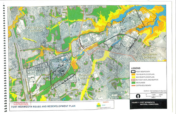
Fort Monmouth, the 1,126-acre former U.S. Army base spanning portions of Eatontown, Oceanport and Tinton Falls, has a host of developments by different firms either completed, ongoing or just getting under way.
The almost 300-acre Mega Parcel slated to become Netflix Studios Fort Monmouth includes areas within the 100-year flood- plain which are regulated under the DEP’s flood hazard rules. That project is in its earliest stages with no building approvals applications yet. Netflix may adaptively reuse some of the many existing buildings throughout the site but is expected to demolish others to construct 12 production studios and ancillary structures. As described, Netflix will have to comply with the higher elevation rule.
Fort redevelopment projects already approved by the DEP will not be affected by a new flood zone construction rule unless a developer proposes significant changes to their plan, said Sarah Giberson, senior marketing and real estate development officer for the Fort Monmouth Economic Revitalization Authority (FMERA).
“Pre-existing buildings located within flood hazard areas are ‘grandfathered’ from the new rules as long as said buildings aren’t expanded in a significant way beyond their pre-existing footprint,” Giberson explained, adding developments built so far, or in progress, are already adhering to flood measures that would comply with the new rule “if said rules apply to their projects.”
“FMERA’s contracts simply state that the developer is responsible for obtaining all necessary approvals for the project,” Giberson said. “It is the responsibility of the developer and the enforcing agency, in this case the DEP, to ensure compliance with whatever regulations are applicable.”
Oceanport and portions of Fort Monmouth within its borders were severely damaged in Super Storm Sandy in 2012. Afterward, Giberson said, the Army rehabilitated some buildings near surrounding waterways in what is known as the 400 Area, currently occupied by caretaker staff.
“The Inland Flood Protection Rule will serve as a critical component of my administration’s comprehensive strategy to bolster our state’s resilience amid the worsening impacts of climate change,” said Murphy. “As a national model for climate adaptation and mitigation, we can no longer afford to depend on 20th-century data to meet 21st-century challenges. This rule’s formation and upcoming adoption testify to our commitment to rely on the most up-to-date science and robust stakeholder engagement to inform our most crucial policy decisions.”
The measure has received support from organizations including the Sierra Club, Environment New Jersey, the Association of New Jersey Environmental Commissions (ANJEC), The Watershed Institute, the Raritan Headwaters Association, the New Jersey League of Conservation Voters, and the NY/NJ Baykeeper.
“New Jersey’s communities are facing unprecedented threats from the devastating impacts of extreme rainfall events, which are expected to continue to intensify in their frequency and severity,” said DEP Commissioner Shawn M. LaTourette.
“The updated Flood Protection Rules will save lives,” said Jennifer M. Coffey, ANJEC executive director. “These rules use climate change data and modeling projections to regulate how and where development and redevelopment happens. New Jersey is once again leading the way, this time with the first set of rules in the nation to look forward rather than backward to establish floodplains and better manage 100-year storms.”
The DEP commissioned New Jersey-specific studies that confirmed precipitation has increased in the state over the past 20 years and will continue to through the end of this century, the press release stated. The peer-reviewed studies were performed by the Northeast Regional Climate Center, a partner of the National Oceanic and Atmospheric Administration. Key findings showed precipitation amounts that have long guided state policy, planning and development relied upon data obtained through 1999 and did not accurately reflect current precipitation intensity. Figures show precipitation during the 100-year storm is likely to increase by 23 to 50 percent above the 1999 baseline by 2100, officials said.
The DEP has launched a “flood indicator tool” to help the public gauge flood risk and “provide a visual approximation of regulatory jurisdiction on specific parcels.” It is available at dep.nj.gov/inland-flood-protection-rule/flood-tool.
The article originally appeared in the July 6 – 12, 2023 print edition of The Two River Times.


